A potentially active stretch of impactful weather begins across the central U.S. today as a strong upper-level storm system moves out of the Rockies and into the northern Plains with a trailing cold front extending from the Missouri River Valley into the southern Kansas. At the same time, a strong ridge of high pressure remains anchored across the Southeast. With a very warm and moisture-rich air mass already in place, this setup will support multiple rounds of thunderstorms, including a risk for severe weather and flash flooding as the front slowly moves southeast.
Thunderstorms are already moving through portions of the Central Plains and Missouri Valley this morning. This initial activity should continue northeast through the morning while gradually weakening. In its wake, warm and humid air will be drawn northward into eastern Nebraska and western Iowa by an increasingly strong low-level jet. If enough sunshine and heating can occur, a narrow corridor of moderate to strong instability could develop by late afternoon.
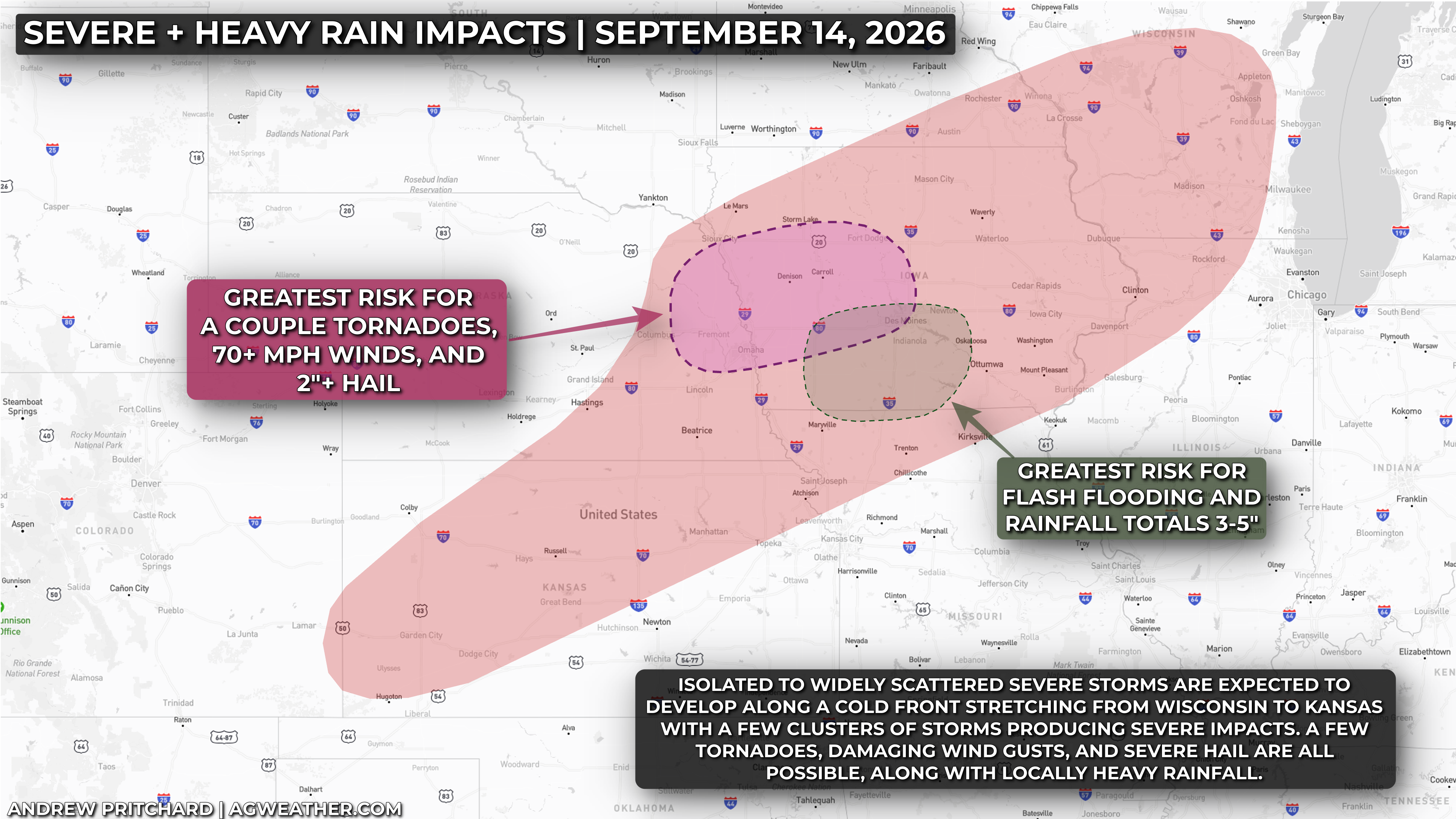
Thunderstorms are expected to rapidly develop along or just ahead of the approaching cold front, initially in an environment supportive of supercells across eastern Nebraska and western Iowa. Large hail will be possible with the first storms, especially any initial supercells, although storms should fairly quickly begin growing into clusters and lines. Damaging wind gusts will become an increasing concern as this transition occurs and storms accelerate eastward into Iowa.
There will also be a tornado threat, particularly from eastern Nebraska into western Iowa during the late afternoon and evening. A strengthening low-level jet will increase wind shear near the surface, creating an environment that could support rotating storms. Even with ample wind shear, if enough sunshine and heating doesn't occur across this corridor, capping could limit surface based storms and any tonrado risk. However, if a sustained, surface-based supercell can develop, a strong tornado would be possible. Today's tornado risk is quite low-confidence given questions about heating in the wake of morning storms, but still needs watched closely into the evening.

Farther west and south, additional thunderstorms are possible from eastern Colorado into western and northern Kansas this afternoon. These storms will generally have weaker wind shear to work with, but steep lapse rates and hot conditions could still support isolated severe wind gusts with any storms that develop.
The more organized severe weather threat should remain focused farther northeast across eastern Nebraska and western Iowa.
By tonight, attention will increasingly turn toward flash flooding. Deep moisture will be present along the front across central and southern Iowa, and as the low-level jet increases the risk for repeated rounds of thunderstorms producing torrential rains running over the same areas will also increase. The strongest signal is across southwestern and central Iowa, including the Des Moines area and locations south and southwest, where forecast guidance supports widespread 3–5 inch rainfall totals with localized amounts potentially reaching 3–6 inches. A Moderate Risk for excessive rainfall is in place for this area, with urban locations, low-lying areas and low-water crossings south of I-80 particularly vulnerable.

Surrounding the more significant flood risk across central and southern Iowa, additional pockets of heavy rainfall and flash flooding are possible from eastern Nebraska through the rest of Iowa and into portions of the Upper Midwest. Thunderstorms and torrential rainfall could continue well into the overnight hours before gradually shifting east early Tuesday.
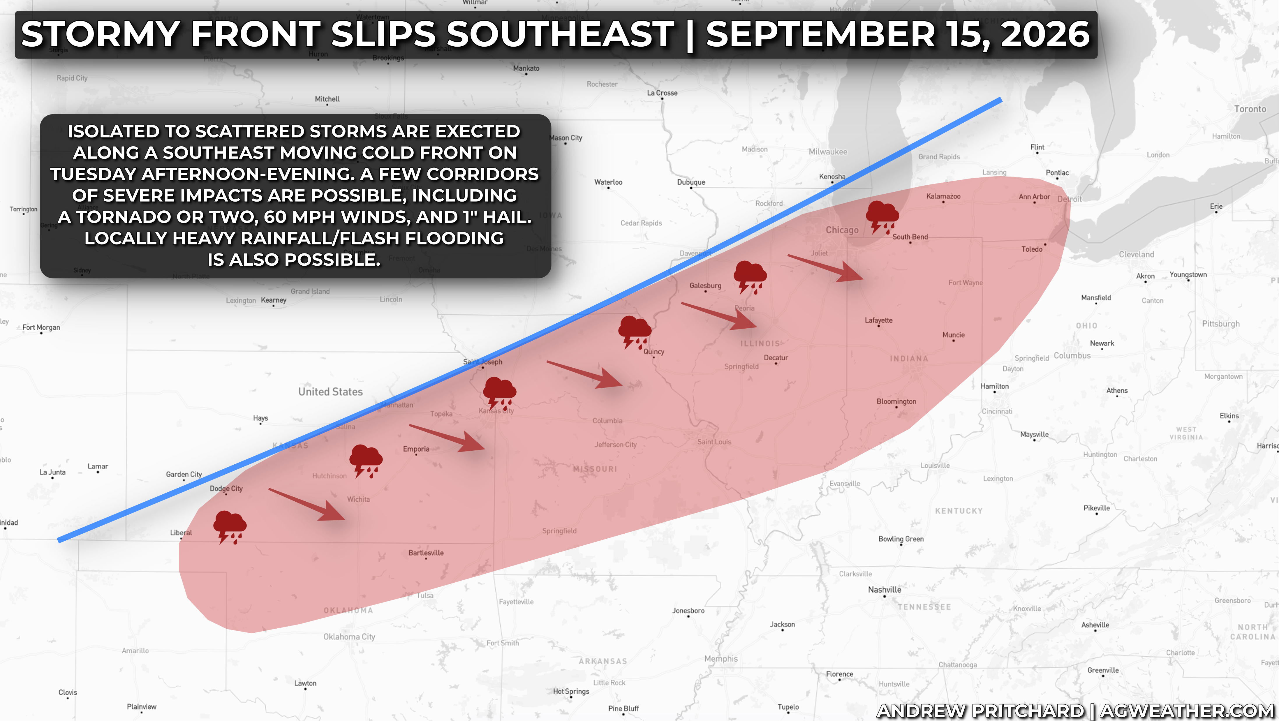
The risk for severe thunderstorms and pockets of heavy rainfall shifts south and east tomorrow along with the cold front.