
Hurricane Isaias continues to strengthen over the central Gulf of Mexico Thursday afternoon, with maximum sustained winds now near 85 mph. Additional strengthening is expected over the next 24 hours as Isaias moves over very warm Gulf waters, with the National Hurricane Center forecasting the storm to reach winds near 110 mph by Friday morning. However, increasing wind shear may cause some weakening as the hurricane approaches the northern Gulf Coast. Regardless, Isaias is expected to remain a dangerous hurricane as it makes landfall somewhere along the Alabama or western Florida Panhandle coastline late Friday night into early Saturday morning.
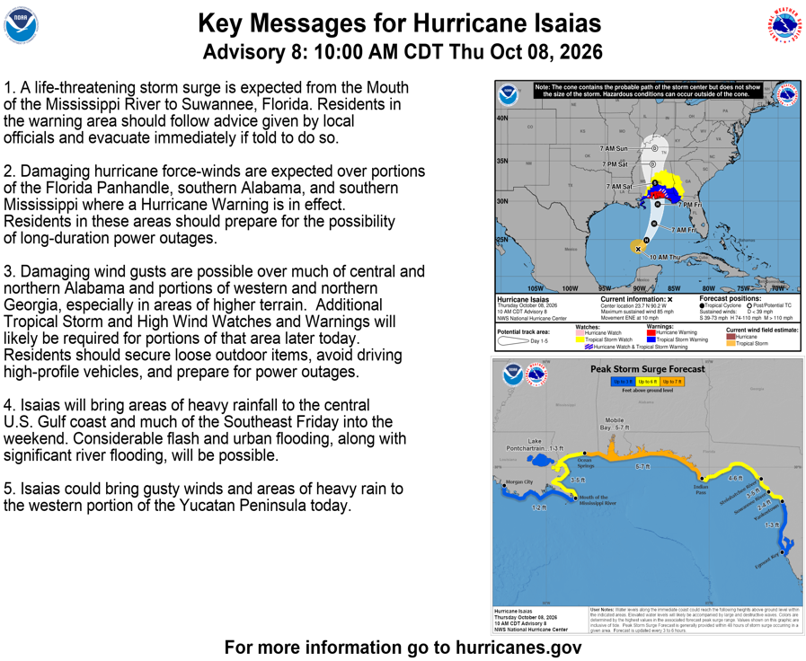
Conditions will begin deteriorating along the northern Gulf Coast during the day Friday, with the most significant impacts expected Friday evening through Saturday morning. Damaging hurricane-force winds are expected across portions of southern Mississippi, southern Alabama, and the Florida Panhandle, where widespread tree damage and potentially prolonged power outages are likely. Strong winds will also extend well inland as Isaias accelerates northward Saturday, with damaging wind gusts possible across central and northern Alabama and portions of western and northern Georgia. In addition to the wind threat, life-threatening storm surge is expected along portions of the northern Gulf Coast, while widespread rainfall totals of 3–7 inches, locally approaching 10 inches, could lead to significant flash flooding and river flooding. These impacts may disrupt agricultural operations, damage infrastructure, and make travel hazardous across a large portion of the Southeast.
Another concern with Isaias will be the potential for tornadoes developing within its outer rain bands, particularly along and east of the storm's track. The Storm Prediction Center has outlined a Slight Risk (Level 2 of 5) for severe thunderstorms across southern Alabama, the Florida Panhandle, and southwestern Georgia Friday night into early Saturday morning. As the hurricane moves inland Saturday, the tornado threat is expected to spread northward into eastern Alabama and western Georgia, where another Slight Risk is in place. Strong low-level wind shear associated with the hurricane will support rotating thunderstorms capable of producing tornadoes, including during the overnight hours Friday night and early Saturday when these storms may be particularly difficult to recognize and respond to.
While confidence is increasing in a significant hurricane impact across the northern Gulf Coast and Southeast, some uncertainty remains regarding the exact track, intensity, and timing of Isaias as it approaches landfall. The storm's relatively compact circulation and favorable ocean conditions could support additional strengthening, although increasing wind shear may work against that process Friday. Even relatively small adjustments in the track could shift the corridors of strongest winds, heaviest rainfall, and greatest tornado potential. Isaias is expected to weaken as it moves inland Saturday, but gusty winds, heavy rainfall, and localized severe weather could continue across portions of the Southeast into Sunday.
Significant tornado risk could ramp up as early as Friday night as the outer bands of Isaias come ashore:

The risk for tornadoes likely peaks with outer bands streaming ashore long after the center of Isaias has made landfall on Saturday morning:
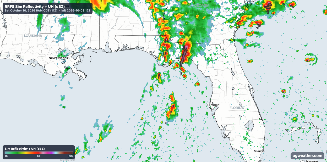
Isaias quickly becomes a hybrid style storm with a highly shear warm sector that is fed with a continuous stream of unstable, warm and humid air:

The temperature plot almost resembles a springtime mid-latitude cyclone over the Central U.S.

Extremely strong winds just above the surface aid in drawing this unstable warm sector northward, while also providing significant wind shear to organize storms and help them rotate, spawning tornadoes:

Current forecast precipitation totals through Saturday:

Current projected maximum wind gusts as forecast by the RRFS:
