
The past week has been extremely active from the Central and Southern Plains into the Midwest, with a series of storm systems bringing damaging tornadoes, destructive hail, and widespread straight-line wind damage from April 22–28. In areas that saw repeated rounds of storms, flash flooding was also reported, with corridors of 2–4” rainfall totals stretching from Kansas to Ohio and south to the Gulf Coast.
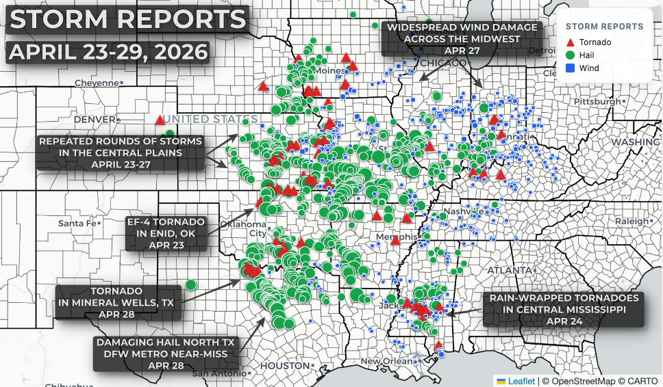
Among the hardest-hit areas was Enid, Oklahoma, where an EF-4 tornado caused significant damage to neighborhoods and industrial areas late in the evening on April 23.

Repeated rounds of storms brought all severe weather hazards to portions of the Plains and Midwest from April 23–27, as the atmosphere continued to reload with deep Gulf moisture beneath fast jet stream flow. This pattern was supported by persistent upper-level low pressure over the central U.S. and a ridge of high pressure over the Southeast. Damaging hail and straight-line winds were the primary hazards, though a few tornadoes were also reported.

In some areas, the shift from long-duration drought to heavy rainfall has been dramatic. Many locations picked up 2–4”+ of rain over the past week, leading to standing water and tight windows for early spring fieldwork.

A pair of fast-moving QLCS events (linear storms with bowing segments and embedded circulations) brought 70+ mph straight-line wind gusts across Missouri, Illinois, and Indiana on April 27, downing trees and power lines. At least one rain-wrapped tornado caused damage in the community of Germantown, Illinois, with additional corridors of damage still being surveyed by the National Weather Service.

The Dallas-Fort Worth metroplex narrowly avoided a major hail event on April 28, as supercell thunderstorms producing baseball-sized hail tracked just to the west. Mineral Wells, Texas, was not as fortunate, with a rain-wrapped tornado causing extensive damage in an industrial district earlier in the day.


The pattern begins to quiet down into late April and early May as a large Great Lakes low pushes cooler air southward into the central U.S., disrupting the active storm track and limiting the northward transport of deep moisture. A window remains for beneficial rainfall along the Gulf Coast from Texas to Georgia, but widespread severe weather is expected to take a pause until at least the second week of May.
